this is where we've started our hike...
 nice "civilized " path, easy to follow...
 but as we went higher and higher there were more stones and less trees
 we followed the green marks and went all the way up there (the red arrow)
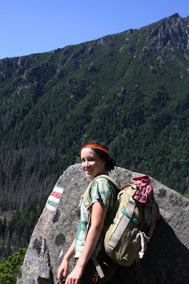
 our team - on top of the mountain...
 looking down on the valley we've just climbed...(you can see the path little bit in the middle)
 rocks all around us...
 we took off our shoes and relaxed for a while, checked the map, had our lunch...
 and continued our journey up the mountain...
 ..remember when I said we were going up there? - well, up there is now down there on the right side of the picture...
 we followed the marks - yellow ones this time...
 and we went up there...
 there were chains to help us climb the mountain...in real life it looked much more dangerous than this...
 and the mountain goat followed us around - you see the "U" of blue sky on the left? - that's where we've crossed the mountain top...
 on the way down...
 there were storm clouds for a while but luckily the sun came out again...
 another little lake. close to the last stop of our trip...
 and now, I know why water and food is so expensive up there - all has to be carried in backpacks by men -as there is only a narrow path leading up to the mountains...
 on the way home, just down, down, down...
 it took us 10 hours of walking, climbing and slipping down and up the hills.
 nice "civilized " path, easy to follow...
 but as we went higher and higher there were more stones and less trees
 we followed the green marks and went all the way up there (the red arrow)
 our team - on top of the mountain...
 looking down on the valley we've just climbed...(you can see the path little bit in the middle)
 rocks all around us...
 we took off our shoes and relaxed for a while, checked the map, had our lunch...
 and continued our journey up the mountain...
 ..remember when I said we were going up there? - well, up there is now down there on the right side of the picture...
 we followed the marks - yellow ones this time...
 and we went up there...
 there were chains to help us climb the mountain...in real life it looked much more dangerous than this...
 and the mountain goat followed us around - you see the "U" of blue sky on the left? - that's where we've crossed the mountain top...
 on the way down...
 there were storm clouds for a while but luckily the sun came out again...
 another little lake. close to the last stop of our trip...
 and now, I know why water and food is so expensive up there - all has to be carried in backpacks by men -as there is only a narrow path leading up to the mountains...
 on the way home, just down, down, down...
 it took us 10 hours of walking, climbing and slipping down and up the hills.
the map says it's only 25 km and 1050 m height difference (the highest point was 2060 m. above the sea level), but I feel like I've walked thousands of kilometers...
it was all worth it, and if you ever find yourself in here, with nothing to do, you have to take this hike and see all I've seen.
________
(it is pretty difficult but if I could do it, then you can do it too :) ...but I'd say it's appropriate only for people who are NOT scared of heights and absolutely NOT for kids (at least not the 2nd part of the hike) - but kids could make it up to the "red arrow" and there are beautiful lakes up there and the view is great too)
HIGH TATRAS - from "Stary Smokovec" to "Hrebienok" to "Zamkovskeho chata" to "Teryho chata" through "Priecne sedlo" to "Zbojnicka chata" and back to "Hrebienok"

Absolutely amazing! Thank you for sharing your adventure and pictures.
ReplyDeleteWow!! what a hike!! I think I would have loved it!!!
ReplyDelete